This A-Z map of Southampton features 50 pages of street mapping extending to include: *Eastleigh *Fawley *Hythe *Romsey *Southampton Airport *Totton *Chandler's Ford *Hamble-le-Rice *Hedge End *North Baddesley *Swaythling *West End A large scale city centre map of Southampton is also included. Postcode districts, one-way streets, safety cameras with speed limits and National Park boundaries are featured on the mapping. The index section lists streets; selected flats, walkways and places of ...
Read More
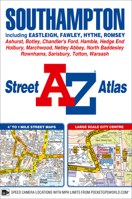
This A-Z map of Southampton features 50 pages of street mapping extending to include: *Eastleigh *Fawley *Hythe *Romsey *Southampton Airport *Totton *Chandler's Ford *Hamble-le-Rice *Hedge End *North Baddesley *Swaythling *West End A large scale city centre map of Southampton is also included. Postcode districts, one-way streets, safety cameras with speed limits and National Park boundaries are featured on the mapping. The index section lists streets; selected flats, walkways and places of interest; place, area and station names; hospitals and hospices covered by this atlas.
Read Less
Add this copy of Southampton a-Z Street Atlas to cart. $69.80, good condition, Sold by Bonita rated 4.0 out of 5 stars, ships from Santa Clarita, CA, UNITED STATES, published 2018 by Geographers? A-Z Map Co Ltd.
Add this copy of Southampton a-Z Street Atlas to cart. $107.25, new condition, Sold by Just one more Chapter rated 4.0 out of 5 stars, ships from Miramar, FL, UNITED STATES, published 2018 by Geographers? A-Z Map Co Ltd.